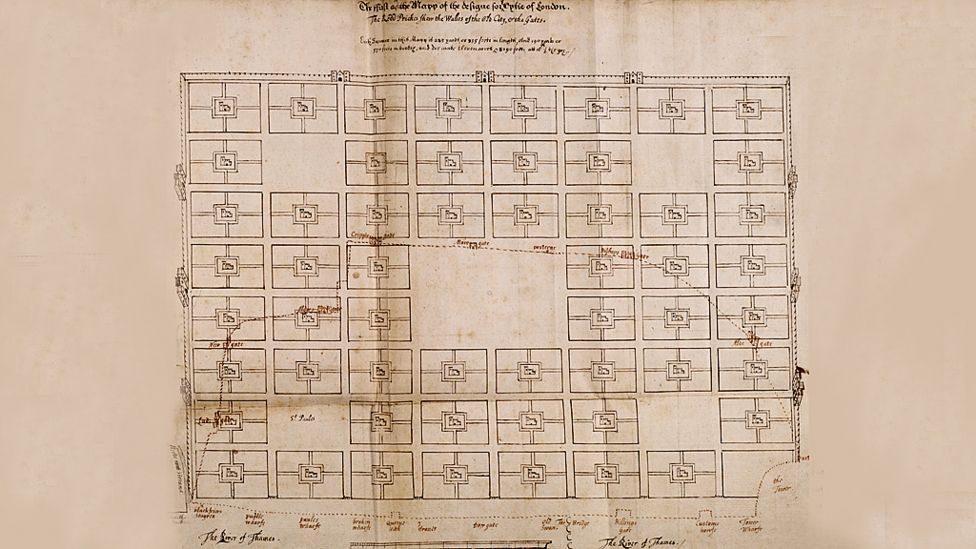
> "A series of public squares, and in the middle of each one a church and churchyard. It can be extended over and over again - it's a perfect grid plan"
Wow - I have been extensively mapping Senegal on Openstreetmap and this is a typical pattern there - only with mosque !
I just like Senegal and I have quite a few Senegalese friends in Paris. My Openstreetmap activity there started with cycling there with no usable maps at all in 2008... Some time after coming back I discovered OSM and began making the maps I would have liked to have - also it was a way to remain connected to Senegal. A few years later, with almost 400k changes in 750 commits, Senegal has turned into the main nexus of my mapping activity and I'm now in touch with some of the local mappers. Open JOSM and look at the changelog of just about every object in the Dakar region and you'll likely find my name in half of them !
I'll be in Dakar at the end of the month by the way, for a couple of week with four of my daughters and I intend to join some OSM meetups there.
Did you mean "New England", like the US Northeast? Because as a lifelong New Englander, I find that a terrible inaccurate statement. There's a Town Common (if it hasn't been converted into a parking lot!) and then cow paths radiating out from there.
>Charles attempted to introduce religious freedom for Catholics and Protestant dissenters with his 1672 Royal Declaration of Indulgence, but the English Parliament forced him to withdraw it
If you want examples of monarchy being worse than democracy, you certainly have plenty of examples with the 2 Charles (There wasn't a civil war for no reason), but there are plenty of examples of democracy being worse than an autocratic system
It was a turbulent time. England(+) had just emerged from a period of Puritan military dictatorship following the overthrow of Charles I. We went from an absolute monarch to a dictator to an absolute monarch to a limited monarchy in 1688. Arguably the UK wasn't a fully parliamentary democracy until the Parliament Act 1911.
"Dictator" implies illegitimacy, unpredictability, or spontaneity -- coming to power by some sort of coup or political surprise. More importantly, it implies being entirely unfettered by law, custom, and the wills of one's subjects -- like the Roman dictators were -- which isn't even true of Cromwell, and certainly isn't true of the kings.
You'll find in most definitions, people go out of their way to not lump Kings in with dictators. Because Kings are the dictators we like for some weird reason. And it usually leads to bizarre contortions.
Even with your very specific definition, it pretty much applies to a whole bunch of kings.
edit: hah, found a blatant example from dictionary.com
Dictator: a person exercising absolute power, especially a ruler who has absolute, unrestricted control in a government without hereditary succession.
How weird that you escape the title "dictator" just by dictating that your kids will be the dictator after you!
There are some thoughts that an aspiring absolute monarch should be very careful not to think; and wanting to make money off a natural disaster is pretty sleazy thinking anyways. I agree, though, that imprisonment probably isn't the right response...
I don't think they're claiming copyright; that's just a boilerplate statement alluding to the fact that just because you see it here on the public internet doesn't mean you shouldn't do your own research to find out whom if anyone has copyright.
You can claim whatever you want. You can claim the sky is made of cheese. Don't make it true.
It's debatable whether, under UK law, you can claim copyright on an image that's just a straight scan of a public-domain/out-of-copyright image. Usually you need to do some sort of work to get the "sweat of the brow" copyright protection. Though it's quite common for places that scan images (like libraries) to claim copyright.
This is a big problem when OpenStreetMap mappers want to trace from an old map.
British copyright law is relatively strict. Given that these were submissions to a royal competition it's entirely possible they're subject to perpetual crown copyright.
I believe in the UK you can hold the copyright to the scan/photo of an artwork or image that is out of copyright. So the digital versions of these images are relatively new and the copywrite would be held by the person making the copy.
Are digitised copies of older images protected by copyright?
Simply creating a copy of an image won’t result in a new copyright in the new item. However, there is a degree
of uncertainty regarding whether copyright can exist in
digitised copies of older images for which copyright has
expired. Some people argue that a new copyright may
arise in such copies if specialist skills have been used
to optimise detail, and/or the original image has been
touched up to remove blemishes, stains or creases.
However, according to the Court of Justice of the
European Union which has effect in UK law, copyright
can only subsist in subject matter that is original in the
sense that it is the author’s own ‘intellectual creation’.
Given this criteria, it seems unlikely that what is merely
a retouched, digitised image of an older work can
be considered as ‘original’.
It's possible to create multiple derivative works of an out-of-copyright work, each of which will carry its own copyright. E.g. modern Sherlock Holmes stories. The question that matters is whether the scan involved enough creative work to qualify for copyright in its own right; as the sibling says, a simple scan won't, but a thorough restoration might.
What amazes me is how small London was then compared to the huge thing it is today. What constituted "London" in Wren's plan is like a small bit of one part of the city today. I mean, it makes sense when you think about it, but it was just surprising to see it visualized.
London itself, as in the City of London, is still only a square mile, it's even called 'The Square Mile'. And the City of London is more-or-less based on the borders of the old Roman city of Londinium. Parts of the Roman city walls are still around today.
Greater London is an amalgamation of the neighbouring boroughs that grew and merged into the London metropolis today. Eg, Westminster, Kensington and Chelsea, Hammersmith and Fulham, Camden, etc.
You can see which borough you're in by looking at the street signs.
Greater London consists of many boroughs or 'cities', way more than three. Each is its own municipality, just like Westminster.
The City of London happens to be one of the smallest, and least populous.
Edit - on rereading this, I realise you may have been referring to the fact that Westminister has 'City' in its name, whereas most others boroughs use the word 'Borough'. I'm not aware of other boroughs in Greater London that are also 'Cities' in that respect.
I'm not aware of any other London boroughs other than Westminster that actually hold the City status though. Being both a borough and a city is pretty unique I think.
Also interesting, those people live only within 4 electoral wards, whereas there are 25 total electoral wards within the City.
Within the remaining 21 electoral wards, votes are controlled by businesses (mostly banks and the like), and the amount of votes that each business receives depends on it's size.
It's the 'city' proper, i.e. the City of London [1] (sometimes known as the Square Mile) as opposed to the city, London, or the Greater London area. It gets very confusing but, yes, London as most people think of it has got much, much bigger in the last 350 years.
A similar thing happened in Detroit, after the fire of 1805. Augustus Woodward designed a plan for the city which was partially implemented, especially in the large avenues leading out of the city center. [1]
Wow - I have been extensively mapping Senegal on Openstreetmap and this is a typical pattern there - only with mosque !